GIS
Services
Our GIS services deliver accurate spatial analysis and mapping solutions to support smarter decisions and efficient project planning.
Get Started
What We Do
We Create and Deliver Custom, Data-Driven GIS Maps and Spatial
Analysis Reports
At RemoteAnchor, we take pride in delivering accurate geospatial
insights and tailored GIS solutions with a strong focus on
quality, reliability, and client satisfaction.
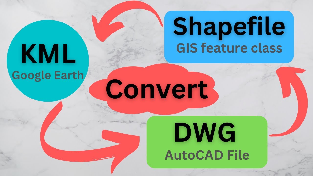
KML, CAD & Shapefile Conversion
We convert geospatial data between KML, CAD, and Shapefile formats with precision, ensuring compatibility, accuracy, and smooth integration across GIS platforms for seamless project execution.
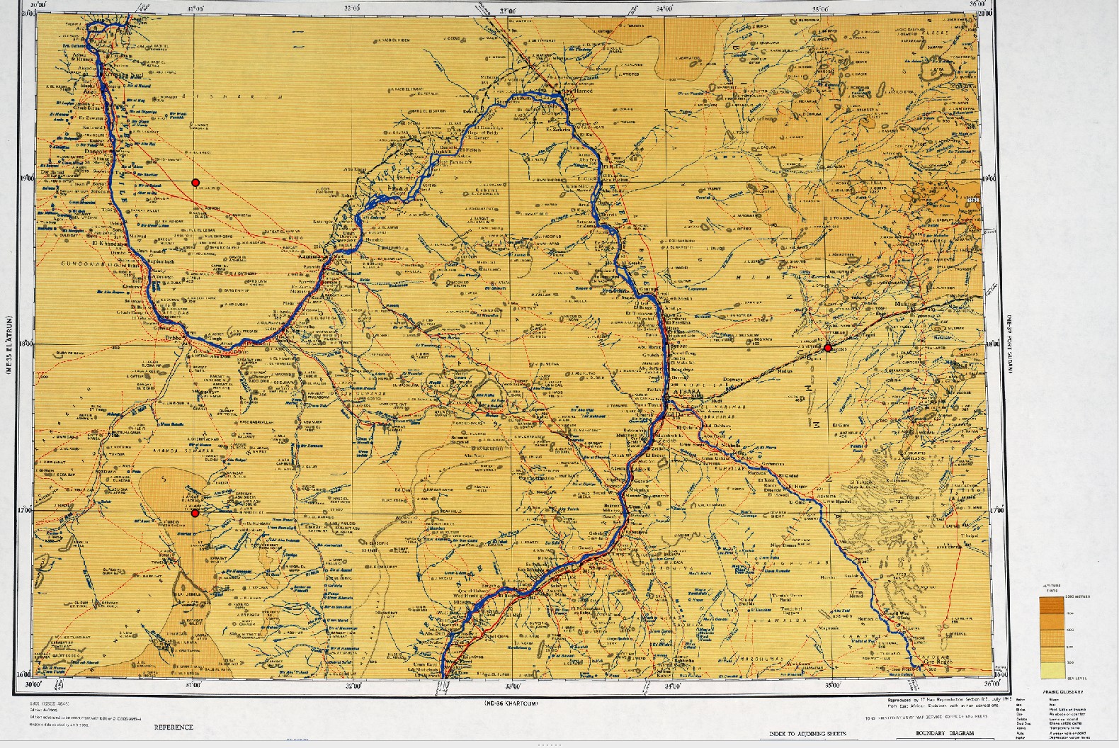
Georeferencing Scanned Maps
We accurately georeference old or scanned maps, aligning them with real-world coordinates to enable spatial analysis and integration into GIS systems for better decision-making and mapping clarity.
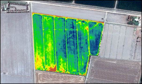
Satellite Interpretation (NDVI)
Our NDVI analysis from satellite imagery helps monitor vegetation health, land use, and crop conditions, offering insights for agriculture, forestry, and environmental management using modern remote sensing techniques.
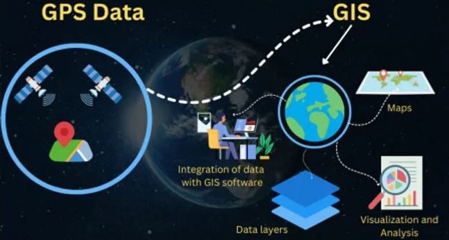
GPS Data Integration
We collect and integrate GPS data into your GIS projects to ensure precise location tracking, mapping, and spatial analysis — ideal for asset management, routing, and field operations.

Mapping & OSINT
We provide customized mapping services using open-source intelligence (OSINT) for risk assessment, surveillance, and planning — combining public data with expert analysis for strategic geospatial insights.
Professional KML, CAD & Shapefile Conversion for Accurate GIS Data Management
Our GIS conversion services provide precise data transformation, optimizing spatial accuracy while ensuring compatibility with multiple platforms and industry standards for smooth project workflows.
We perform detailed georeferencing of scanned maps to align spatial data correctly, improving map reliability and decision-making for your projects.
Satellite image interpretation, including NDVI analysis, is conducted to assess vegetation health and land use, enhancing environmental and resource management.
We deliver accurate GPS data integration and mapping services, supporting GIS specialists and analysts with clear, reliable data for effective planning and analysis.
Enhance Spatial Accuracy with Expert Georeferencing of Scanned Maps
We perform precise georeferencing to align scanned maps with real-world coordinates, enabling accurate integration of historical and non-digital spatial data into modern GIS platforms effectively.Our georeferencing process uses advanced control point matching and coordinate system transformations, ensuring reliable map overlays for improved spatial analysis and decision-making.
By correcting spatial distortions and aligning diverse map sources, we support enhanced data accuracy and usability across environmental, urban planning, and infrastructure projects.
Accurate georeferenced maps enable seamless integration with GPS data and GIS layers, empowering users to visualize and analyze geographic information with confidence and precision.
Accurate Vegetation & Land Insights Through Satellite-Based NDVI Analysis
We use NDVI (Normalized Difference Vegetation Index) satellite data to assess vegetation health, land productivity, and crop performance, supporting smarter decisions in agriculture, land management, and environmental monitoring.
Our interpretation identifies stressed or thriving vegetation zones, enabling precise planning for irrigation, fertilization, or land development while minimizing environmental impact and maximizing resource efficiency.
We integrate historical satellite imagery and seasonal patterns to monitor vegetation changes over time, helping users track reforestation, habitat shifts, and the effects of land use practices.
NDVI reports offer visual insights supporting sustainable land use and planning.
Integrated GPS Data Solutions for Accurate Geospatial Intelligence (headline)
We integrate GPS data into GIS platforms to ensure precise mapping, asset tracking, and spatial analysis—enhancing decision-making for land development, infrastructure planning, and environmental monitoring projects.
Our GPS-based solutions support real-time data collection and location tagging, providing accurate georeferencing for field surveys, utilities, agriculture, and public safety applications.
We optimize GPS integration with custom workflows and data validation, enabling seamless compatibility with CAD, shapefiles, and GIS datasets across desktop and cloud environments.
Strategic Mapping & OSINT Solutions for Smarter Decision-Making
We deliver precise mapping solutions by combining GIS expertise with OSINT (Open Source Intelligence), enabling clients to analyze geographic trends, monitor regions, and make informed strategic decisions.
Our maps integrate geospatial data, public records, satellite imagery, and open-source content to create actionable intelligence for urban planning, environmental studies, and humanitarian or security-focused missions.
Our OSINT-informed maps enhance visibility into conflict zones, infrastructure gaps, and socio-political landscapes, empowering organizations to act proactively and allocate resources more effectively in critical regions.
Using GIS tools, we create scalable maps supporting spatial analysis, awareness, and reporting for governments, NGOs, and private-sector stakeholders.
